STAC#
STAC - Spatio-Temporal Asset Catalog
STAC - background#
Started in 2018, rapidly developing
New de facto metadata and search standard
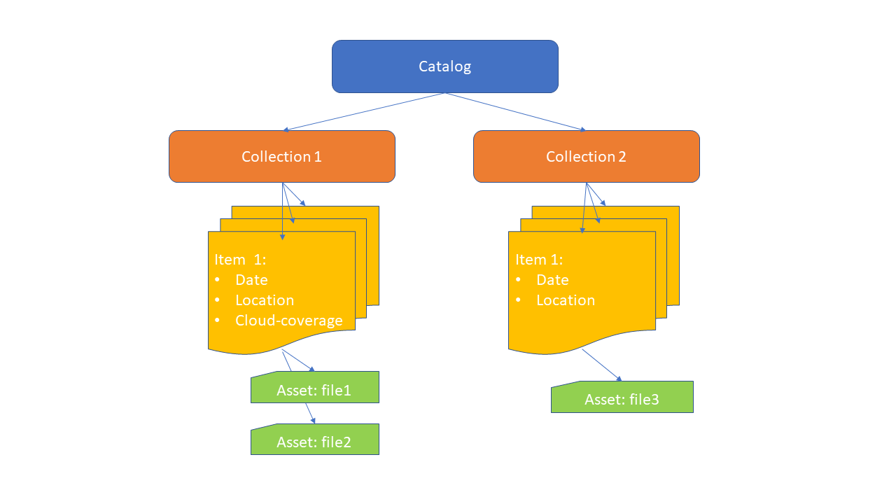
Describes datasets at the level of individual files
It is most commonly used for remote sensing data, but it is suitable for any data with time and location information.
Users: ESA, USGS, Microsoft Planetary computer, Google Earth Engine
In Finland: FMI and CSC.
STAC concepts#
Search with STAC API#
Suitable also for very big datasets
Main focus on Item level
Search criteria:
Collection
Location: point, bbox, GeoJSON polygon
Time
Optional other Item values, for example cloud coverage
Tools for working with STAC#
In web browser: STAC Browser, STAC Index
QGIS: STAC plugin
Python: pystac-client, stackstac, xarray and dask
R: rstac, gdalcubes
PDAL: STAC reader
ArcGIS for Python API
Java, Julia, Ruby, Scala…
CSC Paituli STAC, Finnish spatial datasets#
~175 different datasets, inlcuding:
-
LUKE, erosion risk maps
LUKE, topographic wetness index
LUKE, snow damage risk
NLS, orthophoto and infrared orthophoto*, 1996->
NLS, basic and topographic maps*, 2005->
FMI, historic weather in 10km grids*: min/mean/max temperature, precipitation, snow, sea level air pressure, humidity, radiotion, 1961->
-
Finnish Forest center, Forest stand class
FMI, Wind
GTK, Superficial deposits
NLS, Orthophoto*
MAVI, Field parcels
SYKE, Corine Land Cover
SYKE, Vegetation height
-
ESA/FMI, Sentinel-1 daily and 11 days backscatter mosaics: VV and VH polarisation.
ESA/FMI, Sentinel-2 11-days and annual surface reflectance mosaics.
ESA/SYKE, Sentinel-2 monthly index mosaics: NDVI, NDBI, NDMI, NDSI, NDTI.
ESA, Sentinel-1 backscatter tiles: VV and VH polarisation.
USGS/SYKE, Landsat (4 and 5) yearly index mosaics: NDVI, NDBI, NDMI, NDSI, NDTI.
NLS, Digital terrain model products: DTM, aspect, slope.
Finnish Forest center, Canopy height model.
LUKE, Multi-source forest inventory products.
LUKE, Forest wind damage risk map.
FMI, Daily wind damage risk map.
ESA, Sentinel-2 products, processed to Level-2A (Surface Reflectance), a selection of mostly cloud-free products from Finland. Downloaded to CSC Allas by Maria Yli-Heikkilä (LUKE), Arttu Kivimäki (NLS/FGI) and Matias Heino (Aalto).
* These datasets have several bands in one file, Python stackstac does not support it, but search works.
Next steps
Read more about STAC in general from Paituli STAC description
Test out the example scripts:
Use Paituli STAC, end-point:
https://paituli.csc.fi/geoserver/ogc/stac/v1